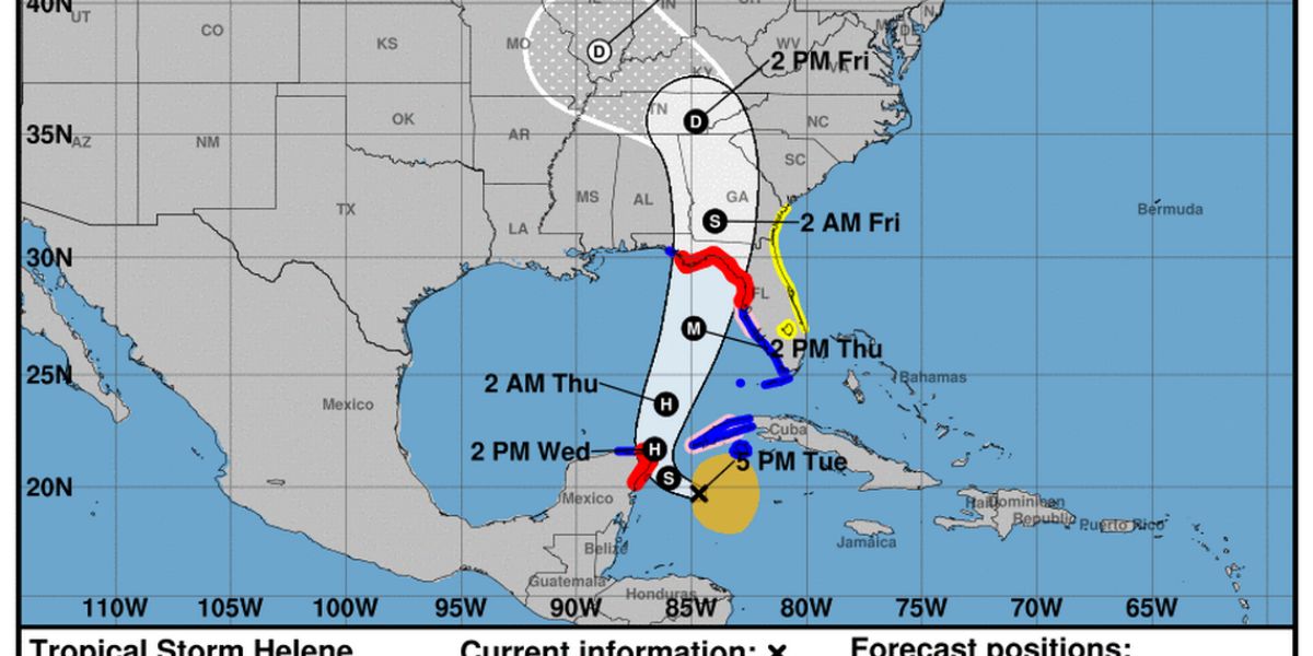
Tropical Storm Helene, which formed early Tuesday in the Caribbean Sea, is expected to intensify rapidly and make landfall in Florida by Thursday, forecasters warn. The National Hurricane Center has predicted that Helene will likely become a Category 3 hurricane as it crosses the Gulf of Mexico, threatening the Florida Gulf Coast with severe winds, storm surge, and heavy rainfall.
As of Tuesday afternoon, the storm was located about 150 miles south of the western tip of Cuba and was moving west-northwest at 12 mph. Officials have issued hurricane and tropical storm warnings for much of Florida’s Gulf Coast, urging residents to prepare for what could be a devastating weather event.
Expected Impact on Florida
Helene is expected to make landfall just south of Tallahassee, though the exact location could shift slightly in the coming days. Forecasters emphasized that the storm is unusually large for its latitude, and its effects will likely be felt across a broad region of Florida’s western coast. Alongside high winds, the storm could produce a life-threatening storm surge that reaches far beyond its center.
Residents have begun to secure their homes and stock up on essential supplies as the storm nears. The National Hurricane Center has advised that Helene will likely retain its intensity right up until landfall, making it a dangerous storm for the area.
Impact on Mississippi
While Mississippi is expected to avoid the brunt of Helene’s force, the storm could still bring cooler and drier conditions to the region, according to Jacob Zeringue, a meteorologist at the National Weather Service in Slidell.
Zeringue explained that Mississippi’s coast, particularly Harrison and Jackson counties, may experience some minor rain showers, with up to 2 inches of rain possible in eastern Jackson County. Gusty winds of 10-15 mph could affect boaters, creating choppy waters on the Mississippi Sound. However, these winds are expected to diminish by Friday.
Unlike previous storms, such as Hurricane Francine, which brought significant storm surge and tornado warnings to Mississippi’s Hancock County, Helene’s impact on Mississippi will likely be much less severe. Winds from the north could result in lower humidity and temperatures in the 70s and 80s by Thursday and Friday.
Preparing for Helene
Helene is predicted to strengthen over record-warm waters in the Gulf of Mexico, potentially reaching peak power in the next 48 hours. The National Hurricane Center warns that favorable conditions, such as decreasing wind shear, could help the storm maintain its strength as it approaches the Florida coast.
The full extent of Helene’s impact remains uncertain, but forecasters recommend that residents in affected areas stay updated on the storm’s progress and prepare for the worst.


