 by
by Washington, D.C. — A weak La Niña pattern has now settled into place, and federal forecasters say it is expected to influence U.S. weather through the start of winter and into early 2026. The National Oceanic and Atmospheric Administration (NOAA) confirmed Thursday that while La Niña conditions are present, their strength remains limited — a factor that could soften some of the typical winter impacts Americans associate with the pattern.
According to NOAA, La Niña’s influence on day-to-day weather is expected to increase through December, even as other large-scale atmospheric patterns work alongside it to shape winter conditions across the country.
What La Niña means for winter weather
La Niña is one phase of the El Niño–Southern Oscillation (ENSO), a recurring climate cycle driven by changes in Pacific Ocean temperatures and atmospheric circulation. The cycle has three phases:
- La Niña, marked by cooler-than-average Pacific waters
- El Niño, marked by warmer-than-average waters
- ENSO-neutral, when temperatures remain close to average
Historically, La Niña winters tend to bring colder and snowier conditions to the Northern Tier and Pacific Northwest, while the southern U.S. often experiences warmer and drier weather.
However, NOAA emphasizes that this year’s La Niña is relatively weak, which means its classic impacts may not appear as clearly or consistently as in stronger La Niña winters.
Why this La Niña may feel different
Forecasters caution that La Niña alone does not control winter weather. Instead, it interacts with several other atmospheric patterns that can amplify or dampen its effects.
NOAA says three key patterns — the North Atlantic Oscillation (NAO), Arctic Oscillation (AO), and Western Pacific Oscillation (WPO) — will play a major role over the next couple of months.
At the moment, both the NAO and AO are signaling a more amplified jet stream across the Lower 48. This setup typically supports stormier and more variable weather, especially as November transitions into December.
Read Also: Here’s How Much Snow Pittsburgh Could See This Weekend, According to NWS Map
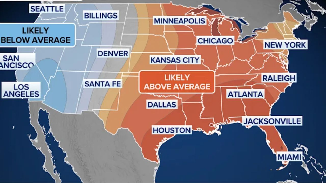
East vs. West temperature divide emerging
The Western Pacific Oscillation is also contributing to the evolving pattern. Current signals suggest:
- Warmer and wetter-than-average conditions developing across much of the eastern United States
- Cooler-than-average conditions persisting across California and the Pacific Northwest
When combined with La Niña, these patterns point to a mild and unsettled end to November for the East, while the West continues to see lingering cooler conditions.
Arctic air still possible as December unfolds
Despite the current warmth projected in the East, NOAA’s Climate Prediction Center warns that La Niña’s growing influence in December could still allow bursts of Arctic air to funnel into the Lower 48.
These cold intrusions could bring sharp temperature drops and snow chances, especially in northern regions, even if the overall winter pattern remains mixed.
Forecasters note that weak La Niña winters often produce greater swings, alternating between mild periods and brief but intense cold snaps.
How long La Niña is expected to last
NOAA says confidence is increasing that La Niña will fade during the first part of 2026. Current projections favor a transition to ENSO-neutral conditions sometime between January and March 2026.
This shift could have important implications for late winter weather.
What ENSO-neutral could mean for snowfall
Historically, ENSO-neutral winters have been linked to increased snowfall in parts of the Northeast, particularly when cold air and active storm tracks align.
While it’s too early to determine exact outcomes, forecasters say the potential transition away from La Niña could reopen the door for more frequent snow events later in winter, even if early winter remains inconsistent.
Big picture: winter still evolving
NOAA meteorologists stress that winter forecasting is complex, especially during weak ENSO events. Rather than one dominant driver, this season is likely to be shaped by interacting patterns, resulting in sharper contrasts and rapid changes from region to region.
For now, the takeaway is clear:
- La Niña will influence early winter, but not dominate it
- Other atmospheric patterns will play a major role
- A shift toward ENSO-neutral conditions is likely in early 2026
Residents are encouraged to keep monitoring updated forecasts as winter unfolds, especially as December approaches and Arctic air becomes more capable of reaching the Lower 48.
Do you typically notice stronger winter impacts during La Niña years where you live? Share your experience and expectations in the comments below.