 by
by Albuquerque, New Mexico — Drivers across parts of New Mexico are being urged to use extra caution overnight and into Monday morning as freezing fog develops, creating the potential for slick roads, poor visibility, and hazardous travel, according to the National Weather Service (NWS) in Albuquerque. While the early-week concern centers on icy conditions, forecasters say a dramatic warm-up and strong winds are set to follow later in the week.
Freezing fog threat overnight into Monday morning
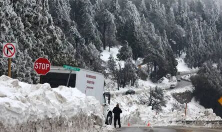
The NWS says patchy freezing fog is expected to form late tonight, with the highest risk window between 4 a.m. and 8 a.m. Monday. During this period, visibility could drop to less than one-half mile in some locations, particularly across the southeastern plains of New Mexico.
Where fog forms and temperatures remain at or below freezing, moisture can freeze on contact, leading to slick conditions on roads, bridges, and overpasses. These icy patches may be difficult for drivers to see, especially before sunrise.
Forecasters emphasize that freezing fog can be especially dangerous because roads may appear merely damp while actually being icy.
Areas most likely to be impacted
While freezing fog is expected to be patchy rather than widespread, the greatest concern is across southeastern New Mexico, where overnight temperatures are forecast to hover near the freezing mark.
Major routes that could be affected include U.S. 70, U.S. 60, U.S. 84, U.S. 380, and surrounding state highways. Drivers using rural roadways should be particularly cautious, as these areas tend to ice up faster and may see less traffic treatment.
Northern and eastern parts of the state will see much colder overnight lows, increasing the risk for ice wherever fog or lingering moisture is present.
Overnight temperatures drop into teens and 20s
Temperatures late tonight are expected to fall into the teens and 20s across much of northern and eastern New Mexico. Colder pockets are forecast near Gallup, Grants, Clayton, and Raton, where sub-freezing air will be firmly in place.
In central areas, Albuquerque and Socorro are expected to bottom out around the mid-30s, slightly warmer but still cool enough for patchy fog to create slick spots in low-lying or shaded areas.
Farther south and east, communities such as Roswell may see overnight lows near 30 degrees, placing them squarely in the zone where freezing fog could pose the greatest risk.
Travel safety guidance from forecasters
The National Weather Service urges motorists to take simple but important precautions during the Monday morning commute:
- Slow down and increase following distance
- Use low-beam headlights in foggy conditions
- Be alert for black ice, especially on bridges and overpasses
- Allow extra travel time, particularly on rural highways
Even a thin layer of ice can significantly reduce traction, and sudden braking or sharp turns may lead to loss of control.
Rapid warm-up arrives Tuesday
After the chilly and potentially icy start to the week, forecasters say conditions will change quickly. By Tuesday, a rapid warm-up is expected across much of New Mexico, with temperatures climbing well above seasonal averages.
Read Also: NOAA: Weak La Niña to Shape Early Winter Weather, ENSO-Neutral Pattern Favored in 2026
Some areas could approach near-record warmth by midweek, offering a sharp contrast to the freezing fog concerns of Monday morning. While the warmer air will help eliminate lingering ice, it will introduce a new weather hazard: strong winds.
Strong winds possible midweek
From Wednesday afternoon through late evening, the NWS is monitoring the potential for strong west winds statewide. While confidence is still moderate, forecasters note a low but notable chance of wind gusts reaching 50 to 60 mph along parts of the I-25 corridor between Las Vegas and Raton.
Gusty crosswinds could make travel difficult for high-profile vehicles, including trucks, RVs, and trailers. Loose outdoor items may also be blown around, creating additional hazards.
What residents should do now
Weather officials encourage residents to stay alert as conditions evolve over the next few days. Ahead of Monday morning, drivers should plan for reduced visibility and icy spots, especially in fog-prone areas.
Before midweek, residents are advised to secure outdoor items, such as trash bins and holiday decorations, ahead of the expected increase in wind.
More updates expected
The National Weather Service will continue issuing updates as freezing fog develops overnight and as the midweek wind potential becomes clearer. Conditions may vary significantly from one community to another, making it important to monitor local forecasts closely.
For now, the message is clear: use caution overnight and Monday morning, then prepare for a much warmer — and windier — stretch of weather across New Mexico.
Have you experienced freezing fog or sudden icy roads in your area before? Share how conditions look where you live in the comments below.