 by
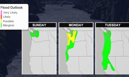
by Hartford, CT – August 1, 2025 – Connecticut is preparing for a powerful round of heavy rainfall that could bring dangerous flooding to cities and rural areas alike. A Flood Watch is in effect for the entire state from 2 p.m. Thursday through 2 p.m. Friday, with the National Weather Service warning of rising rivers, road washouts, and potential power outages.
Rainfall Expected Across the State
Forecasters at the National Weather Service in Boston estimate 1 to 2 inches of rainfall across most of Connecticut, with up to 3 to 4 inches possible in central and southern areas. Cities including New Haven, Waterbury, Danbury, and New London are expected to receive the heaviest downpours. The intense rain could cause rivers and streams to swell and result in standing water on roads and in low-lying areas.
Travel Risks During the Rain
Officials warn that driving could become hazardous during the heaviest periods of rain, especially along major highways such as I-84, I-91, and Route 15. Flash flooding and water pooling may reduce traction and visibility. Motorists are urged to avoid unnecessary travel during peak storm hours and never drive through flooded roads.
Safety Tips
With the ground already saturated from a wetter-than-usual July, flash flooding could occur more quickly than usual. Residents should:
- Avoid travel during heavy rain unless absolutely necessary
- Move valuables from basements or flood-prone areas
- Stay updated via local emergency alerts and weather reports
- There is also a risk of power outages if storm drains overflow or if strong wind gusts accompany the heaviest rainfall bursts.
What’s Next
Flood warnings are expected to remain in effect until at least Friday afternoon. Additional alerts may be issued if rainfall intensifies overnight. Residents are advised to monitor official channels and prepare now for possible disruptions.