by
by Charlotte, North Carolina — Low clouds hang over the Piedmont this morning, keeping temperatures mild and roads damp as Charlotte eases into the final weekend of December. At first glance, it feels more like early fall than the heart of winter. But forecasters say this calm, warm pattern will not last long, with rain and a sharp cooldown lining up just as New Year’s travel begins.
According to the National Weather Service, the region is entering a classic temperature swing pattern, moving from springlike warmth to winter chill within just a few days.
Quiet Start Friday With Mild Conditions
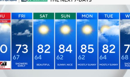
Friday remains mostly uneventful across the Charlotte metro area. Skies stay gray, but no rainfall is expected during daylight hours, keeping travel smooth along I-77, I-85, and local commuter routes. Afternoon highs hold in the upper 50s, well above seasonal norms.
Humidity lingers, however, leaving pavement slightly damp in spots. While impacts are minimal, drivers should still remain cautious during early morning and evening hours when visibility may dip under low cloud cover.
Saturday Brings Unseasonable Warmth
Saturday delivers the warmest weather of the period and may feel surprising for late December. Sunshine breaks through, pushing afternoon highs into the low 70s — nearly 20 degrees above average for this time of year.
This warmth creates ideal conditions for post-holiday errands, outdoor plans, and regional travel. Winds remain light, and roads stay dry throughout the day. Saturday night also stays mild, with lows only falling into the upper 40s, preventing any cold-weather issues overnight.
Clouds Return Sunday Ahead of Next System
Sunday marks the transition day. Clouds thicken once again, holding daytime temperatures near 59 degrees. While rain stays mostly at bay during daylight hours, the changing sky signals an approaching weather system that will affect the Carolinas early in the workweek.
Travel conditions remain manageable Sunday, but meteorologists advise using the day to prepare for what follows, particularly if planning early-week travel.
Rain Arrives Monday as Temperatures Begin to Shift
By Monday, rain chances increase to around 40 percent as moisture moves across the region. Showers are expected to be scattered but could briefly reduce visibility and slow traffic, especially during the afternoon and evening commute.
Roads may become slick during heavier bursts of rain, though flooding is not anticipated at this time. Drivers should plan extra travel time and expect variable conditions during peak hours.
Freeze Risk Emerges Monday Night
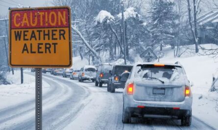
The most impactful change arrives after the rain exits. Cooler air sweeps into the Piedmont Monday night, dropping overnight lows toward 30 degrees. Any leftover moisture on roadways could refreeze, creating isolated slick spots, particularly on bridges, overpasses, and shaded roads.
This freeze risk may catch some drivers off guard after such a warm weekend. Early Tuesday morning commuters should remain alert for patchy black ice, even if roads appear dry at first glance.
New Year’s Week Turns Cooler and More Seasonal
As New Year’s week 2026 begins, the weather settles into a more typical winter pattern. Tuesday and Wednesday remain dry but cooler, with daytime highs in the 40s and nighttime lows dipping into the upper 20s.
While snow is not expected, frost and freeze conditions become a concern for early-morning travel and outdoor activities. The calmer pattern should help travel conditions improve, provided drivers account for colder mornings.
What to Keep in Mind
- Friday: Mild, cloudy, and dry
- Saturday: Unseasonably warm, sunny, and travel-friendly
- Sunday: Cloudy, signaling change ahead
- Monday: Rain develops, slowing travel at times
- Monday night into Tuesday: Freeze risk as temperatures drop
Read Also: Friday Snowstorm Could Bring Up to 8 Inches Across Tri-State Area
The rapid shift from warmth to winter chill makes planning ahead essential, especially for those traveling around New Year’s.
Three-Day Outlook for Charlotte
- Sunday: Cloudy, high near 59°F
- Monday: Chance of rain, high near 70°F
- Tuesday: Sunny and cooler, high near 46°F
Enjoy the warm break while it lasts, but be ready for winter to reassert itself as 2026 begins.
Are you noticing the temperature swings yet, or preparing for icy mornings next week? Share what you’re seeing in the comments below.